
The URA Master Plan is Singapore's statutory land use plan, and Master Plan 2025 (MP2025) is now gazetted and in effect as of December 1, 2025, guiding development for the next 10 to 15 years. To verify how it applies to a specific site, check three sources: the Master Plan Written Statement, URA SPACE, and the List of Gazetted Proposed or Approved Amendments.
TL;DR:
- The maximum plot ratio indicates development capacity but is not guaranteed; real achievable intensity depends on site conditions and approval.
- Changes to zoning and plot ratios are announced through gazetted amendments and can take effect without prior notice, affecting site value and planning.
- Public participation influences land use decisions, with nearly 220,000 contributions shaping major projects like green corridors and housing precincts in MP2025.
- Always verify parcel-specific details through URA SPACE and consult a planning professional to accurately interpret zoning and development potential.
- Land use shifts, such as waterfront rezoning and decentralization, typically unfold gradually over multiple Master Plan cycles, not in a single review.
Table of Contents
- What the Master Plan is and how the review process works
- Headline themes and practical highlights from Master Plan 2026
- How to read zoning, plot ratio and incentive plot ratio rules
- How to monitor amendments and use URA SPACE: step-by-step workflow
- What MP2025 means for buyers, investors and planners
- Historical evolution of the URA Master Plan and its significance in urban development
- How public consultation shapes the Master Plan
- How the Master Plan connects to other planning frameworks
- Key urban planning principles behind the Master Plan's policies
- Common terms and symbols on the Master Plan maps
- Case studies: land use change across past Master Plans
- Reading MP2025 like a planner: what I'd flag first
- One Marina Gardens: a Marina South option worth a look
- FAQ
- Sources
What the Master Plan is and how the review process works
The Master Plan sits below Singapore's long-term Concept Plan in the planning hierarchy. It translates broad strategic directions into site-specific land use proposals covering zoning, density and infrastructure for roughly the next 10 to 15 years, and it carries legal weight because it is enforced through development control. When you apply to build or redevelop a property, your plans are checked against the Master Plan's zoning and intensity provisions.
The Master Plan Written Statement is the formal reference document that interprets what the zoning colors and plot ratio notations on the map actually mean. It spells out permitted uses, definitions and conditions that are not always obvious from the map alone, so it carries more interpretive authority than the colored plan itself.
The Master Plan is reviewed roughly every five years, with public engagement built into the process well before gazette. For MP2025, this meant:
- A draft plan released for public feedback before finalization.
- Extensive engagement sessions, exhibitions and online channels to collect public input.
- A gazette stage that formalizes the reviewed plan as the legally binding document.
Headline themes and practical highlights from Master Plan 2026
MP2025 was gazetted to steer Singapore's physical development over the coming 10 to 15 years, and several themes stand out for residents and buyers. Housing supply features heavily, with new precincts identified for residential development to meet demand across different price points. Car-lite town planning continues to expand, with more towns designed around walking, cycling and transit rather than private vehicle use.
Other notable directions include:
- Nature corridors linking green spaces across the island to support biodiversity and recreation.
- Expanded regional hubs outside the city center to bring jobs closer to homes.
- Coastal and urban resilience measures addressing flood risk and climate adaptation.
- Continued emphasis on heritage conservation alongside new development.
Nearly 220,000 people took part in the Draft Master Plan 2025 engagement process, shaping priorities before the plan was finalized and gazetted. That scale of participation means many of the headline proposals, from new park connectors to housing precincts, reflect direct public input rather than planning decisions made in isolation.
For residents near Marina South, these directions matter directly. The area has been positioned within broader plans for waterfront living and connectivity, and our Marina South Master Plan overview walks through what these directions mean for projects in the district.
How to read zoning, plot ratio and incentive plot ratio rules
Zoning notations on the Master Plan map show the predominant permitted use for a parcel, whether residential, commercial, or mixed. The Written Statement is where these notations get their legal interpretation, including which secondary uses are allowed and under what conditions.
Plot ratio is the figure most buyers misread. The number shown is the maximum permissible intensity for a site, not an entitlement you automatically receive. The competent authority decides actual permitted intensity when a development application is assessed, taking into account site context, infrastructure capacity and urban design considerations.
Before assuming redevelopment potential on any site, work through these steps:
- Confirm the zoning notation and read its definition in the Written Statement.
- Check the plot ratio shown and treat it as a ceiling, not a guarantee.
- Look for incentive plot ratio provisions, which allow higher intensity in exchange for conditions like public space contributions.
- Search the Gazetted Amendments list for any pending changes to that parcel.
- Cross-check the parcel on URA SPACE for conservation status or other overlays.
Pro Tip: Never price a potential redevelopment based on the maximum plot ratio alone. Get a planning consultant to confirm what intensity is realistically achievable before you factor it into an offer.
How to monitor amendments and use URA SPACE: step-by-step workflow
Master Plan amendments happen between the five-year reviews, and tracking them is how you catch changes before they affect value. The List of Gazetted Approved Amendments is the official record of confirmed changes, while a separate proposed list shows amendments still under consideration. Each entry links to a PDF stating the parcel, the nature of the change and the effective date.
URA SPACE complements these lists with parcel-level detail:
- Zoning layer confirms current permitted use and plot ratio for any lot.
- Conservation layer flags heritage or conservation status that restricts alteration.
- Planning decisions layer shows past approvals granted for a site.
- Government land sales layer flags upcoming supply that could affect surrounding value.
| Tool | What it shows | Best used for |
|---|---|---|
| Gazetted Amendments list | Confirmed and proposed changes to zoning or plot ratio | Spotting changes before they take effect |
| URA SPACE zoning layer | Current zoning and plot ratio for any parcel | Verifying a site's baseline entitlement |
| URA SPACE conservation layer | Heritage and conservation designations | Checking redevelopment restrictions |
| Written Statement | Formal definitions and conditions | Interpreting what a zoning code permits |
An amendment becomes effective on its gazette date, and applications already submitted before that date are typically assessed under the rules in force when they were lodged. Keep a watchlist for rezoning near your property, plot ratio increases on neighboring sites, new conservation designations and government land sales notices nearby.
What MP2025 means for buyers, investors and planners
Turning Master Plan signals into a decision means working through a short due diligence sequence before you commit to anything.
- Confirm the zoning and plot ratio for the exact parcel on URA SPACE, not just the general area.
- Check for any Subject to Detailed Control Plan (SDCP) notations that limit what can currently be built.
- Search the amendment lists for pending proposals affecting the site or its immediate surroundings.
- Note any conservation status that would restrict future alteration or redevelopment.
- Request the relevant Written Statement extract if the zoning interpretation is unclear.
These checks should feed directly into how you time an offer, structure a bid or assess upside on a site with unused plot ratio. A parcel with a pending rezoning proposal nearby carries different risk than one with no amendments in sight, and that difference belongs in your price discussions, not just your due diligence file.
For application-level questions, a qualified person such as an architect or planning consultant can interpret Written Statement clauses against your specific site, and URA's own planning officers can clarify how a provision applies in practice. Our unit selection strategy guide walks through HDB and URA checks buyers often miss, and our showflat viewing checklist covers what to verify in person before signing anything.
Pro Tip: When a plot ratio or zoning question gets technical, bring in a structural or planning specialist early. Firms like AEC Technical Singapore outline the practical checks needed before you rely on a plot ratio figure for redesign or redevelopment planning.
Historical evolution of the URA Master Plan and its significance in urban development
Singapore's statutory Master Plan traces back to postwar planning efforts aimed at managing rapid urbanization on a small, dense island. Over successive decades, the plan evolved from a basic zoning tool into a detailed instrument balancing housing, industry, greenery and heritage within a fixed land area.
Each five-year review has reflected the economic and social priorities of its time. Earlier plans prioritized industrialization and public housing at scale, addressing acute housing shortages. Later reviews shifted toward decentralization, pushing commercial activity into regional centers like Jurong and Tampines to reduce congestion in the city core. More recent plans have layered in climate resilience, nature connectivity and heritage conservation alongside continued housing and economic growth.
This evolution matters because the Master Plan is not a static document. It responds to population growth, changing household needs, and environmental pressures, while retaining enough continuity that long-term infrastructure, such as transit lines, can be planned decades in advance. The significance for anyone buying or developing property is that today's zoning reflects accumulated decisions stretching back generations, and understanding that lineage helps explain why certain areas are earmarked for intensification while others remain protected or conservation-zoned. The Master Plan's role as a living, legally enforceable document, rather than a one-time blueprint, is what gives it lasting authority in shaping how Singapore grows.
How public consultation shapes the Master Plan
Public consultation is built into every Master Plan review cycle, not added as an afterthought. Before a draft plan is finalized, URA runs exhibitions, online feedback channels and engagement sessions with residents, businesses, grassroots organizations and interest groups to gather views on proposed land use changes.
This feedback genuinely shapes outcomes. Concerns raised during engagement, whether about preserving a green space, protecting a heritage building or addressing traffic in a growing town, get weighed against technical and land supply constraints before the draft is revised into a final plan. The scale of participation in the Draft Master Plan 2025 engagement illustrates how seriously this input is gathered: almost 220,000 people contributed views before the plan was gazetted.
After the draft stage, the revised plan proceeds to gazette, at which point it becomes legally binding. Even after gazette, amendments can still be proposed and go through their own notification process, which gives residents and stakeholders another point of input on specific parcels. For buyers, this means the Master Plan you see today reflects both expert planning work and layers of public feedback, which is worth keeping in mind when a zoning decision seems to favor community amenities over maximum development intensity on a given site.
How the Master Plan connects to other planning frameworks
The Master Plan does not operate alone. It sits within a planning hierarchy that starts with the Concept Plan, Singapore's long-term strategic blueprint covering a 40 to 50 year horizon for land use, transport and population distribution. The Concept Plan sets broad directions, such as where new towns or transport corridors might eventually go, without specifying site-level detail.
The Master Plan translates those long-term directions into actionable, medium-term proposals with legal force. Where the Concept Plan might indicate a future growth area, the Master Plan assigns specific zoning, plot ratios and development conditions to individual parcels within that area, and it is the Master Plan, not the Concept Plan, that is used to assess actual development applications.
Beneath the Master Plan, more granular instruments like Detailed Control Plans and Subject to Detailed Control Plan (SDCP) notations govern specific sites where planning is still being finalized, often in areas undergoing active transformation. Understanding this hierarchy helps explain why a site might show general zoning intent on the Master Plan but require a separate detailed plan before development parameters are locked in. For planners and buyers alike, checking which layer of this framework applies to a specific parcel avoids assuming certainty where the detailed planning work is still pending.

Key urban planning principles behind the Master Plan's policies
Several recurring principles shape how land use decisions get made across Master Plan reviews. Land optimization is central given Singapore's limited land area: zoning decisions aim to maximize the value extracted from every parcel while balancing competing needs for housing, industry, recreation and green space.
Decentralization has guided policy for decades, pushing commercial and employment nodes away from the city center into regional hubs so residents can live closer to work. Connectivity is another consistent thread, with land use decisions made alongside transport planning so that new housing and commercial precincts align with MRT lines and bus networks rather than being added afterward.
Sustainability and resilience have grown more prominent in recent reviews, reflected in car-lite town design, green corridors and climate adaptation measures for low-lying and coastal areas. Heritage conservation operates as a counterweight to intensification, protecting identified buildings and precincts from redevelopment even where surrounding plot ratios allow for taller, denser construction.
Mixed-use development is also a consistent preference, blending residential, retail and amenity space within the same precinct or even the same building rather than separating functions into single-use zones. Together, these principles explain why zoning outcomes in any given Master Plan reflect a negotiated balance rather than a single objective like maximizing housing supply or protecting green space in isolation.

Common terms and symbols on the Master Plan maps
Master Plan maps use a standardized set of colors and notations, each explained in detail in the Written Statement. Residential zones typically appear in shades indicating density, commercial zones in a distinct color, and mixed-use zones in another, with white or hatched areas often denoting reserve sites or special conditions.
A few terms come up repeatedly and are worth knowing:
- Plot ratio: the maximum permissible ratio of gross floor area to land area for a site.
- Gross plot ratio: the same concept applied across a combined or comprehensive development area.
- Conservation area: a zone where building alterations are restricted to preserve heritage character.
- SDCP (Subject to Detailed Control Plan): a notation indicating detailed planning for that site is still pending.
- Reserve site: land set aside for future use not yet finalized in the current plan.
These notations are deliberately compact on the map itself, which is exactly why the Written Statement exists as a companion document. Reading the map without cross-checking the Written Statement risks missing conditions attached to a zoning code, such as height restrictions or permitted secondary uses that are not visible as a color or symbol.
Case studies: land use change across past Master Plans
Past Master Plan cycles offer concrete examples of how zoning changes translate into visible development. Decentralization policy, consistently reinforced across multiple reviews, is why regional centers such as Jurong East grew from an industrial and residential area into a major commercial hub with office towers, retail and transport interchange, a shift planned and executed over successive Master Plan cycles rather than a single revision.
Similarly, waterfront precincts that were once industrial or port-related land have been progressively rezoned for mixed-use residential and commercial development as part of broader city center expansion plans, with Marina South representing one such area now designated for waterfront residential living with supporting retail and connectivity. Park connector networks have also expanded steadily across reviews, converting originally disconnected green spaces into a linked island-wide system, a direct outcome of the nature corridor principle appearing consistently in recent plans.
These examples illustrate a consistent pattern: major land use shifts in Singapore rarely happen in a single Master Plan cycle. They tend to unfold over multiple five-year reviews, with each cycle building on groundwork laid by the one before it. For buyers and planners, this history is a useful reminder that a site's current zoning may represent one stage in a longer, intentional transformation rather than a fixed, final designation.
Reading MP2025 like a planner: what I'd flag first
The most common mistake I see is treating a plot ratio figure as a guarantee rather than a ceiling. Confirm actual permitted intensity with a qualified person before you price in any redevelopment upside.
For Marina South specifically, the district's waterfront zoning and transit access shape what gets built nearby, including projects like One Marina Gardens near Marina South MRT with its sky terraces and lap pool. Always verify the primary URA documents yourself, and bring in a professional for anything application-specific.
— Velisa
One Marina Gardens: a Marina South option worth a look
If Marina South's zoning and connectivity appeal to you, One Marina Gardens is a condominium located near Marina South MRT in District 01, with convenient access to the CBD and Orchard Road.
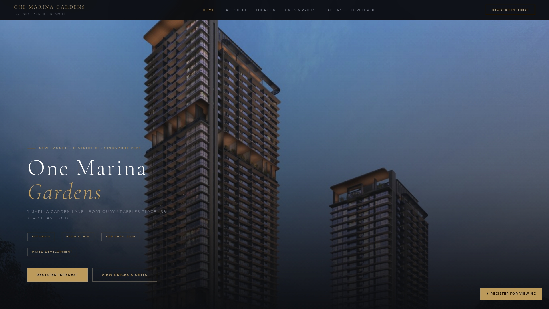
The development offers various unit types across a large number of units, along with facilities such as sky terraces, a lap pool and a childcare centre, as well as on-site retail and dining within a mixed-use precinct.
Before making an offer on any unit here or elsewhere, confirm current zoning and plot ratio details directly through URA SPACE. You can browse available unit types or check the price list to see what fits your budget.
FAQ
How often is the URA Master Plan updated?
The Master Plan is reviewed roughly every five years, with public engagement conducted before each draft is finalized and gazetted. MP2025 followed this cycle, with its gazette taking effect on December 1, 2025.
Is URA a good place to work?
Published, verifiable workplace ratings for URA are not listed in the sources we rely on for this guide. For reliable information on this, check URA's own careers page or a verified employer review platform directly.
What is included in a Master Plan?
A Master Plan includes zoning maps showing permitted land uses, plot ratio figures setting maximum development intensity, and a Written Statement that formally interprets these notations and conditions. It also incorporates conservation designations, reserve sites and notations like SDCP for areas still under detailed planning.
What is the Master Plan in Singapore?
The Master Plan is Singapore's statutory land use plan, legally guiding development for roughly the next 10 to 15 years through zoning and plot ratio controls enforced at the development application stage. The current version, MP2025, was gazetted on December 1, 2025.
How do I check if a specific plot has a pending zoning change?
Search the List of Gazetted Approved Amendments for your parcel and cross-check its current zoning on URA SPACE. Any pending proposed amendment will also appear in a separate list before it is finalized.